# Commit
Stage Two of the Programme is commitment. Here, Participants are required to maintain their membership of WSAP; pay a fee to start this Programme; publicly commit to the philosophy, concept and process of water stewardship through the Verification Programme; gather and understand information about their site’s water impacts and their catchment as a whole; and then develop a Water Stewardship Strategy and a Water Stewardship Plan.
An internal review must be completed by Water Stewardship Asia Pacific to demonstrate compliance with the required indicators and criteria. Once approved the organisation can progress to Stage Three (Implement) of the Programme. Participants must complete an Annual Communication of Progress within 12 months of their internal review.
To maintain the Commit level of verification (if not continuing to Stage Three of the Programme), an Annual Communication of Progress must be submitted every 12 months.
# Step 1 - Gather & Understand
In Step 1, Participants gather and understand information about their site’s water impacts and their catchment as a whole.
# 1.1 Gather information to define the site’s physical scope for water stewardship purposes
# 1.1.1 Provide a map of the physical scope of the site, considering regulatory landscape and zone of stakeholder interests
Defining the physical scope is fundamental to the water stewardship process. It defines where to collect data, where to assess risk and the geographical scope for stakeholder engagement. The physical scope is a different concept than catchment, but they overlap. The definition is:
Physical scope: The land area relevant to the site’s water stewardship actions and engagement. It should incorporate the site and relevant catchment(s) but may extend to relevant political or administrative boundaries. It is typically centered on the site but may include separate areas if the origin of water supply is more distant.
Mapping should include:
- Site boundaries;
- Water-related infrastructure, including piping network, owned or managed by the site or its parent organization;
- Any water sources providing water to the site, including those water sources or abstraction points that are owned or managed by the site or its parent organization and water service provider (if applicable) and its ultimate water source;
- Discharge points and waste water service provider (if applicable) and ultimate receiving water body or bodies;
- Catchment(s) that the site affect(s) and is reliant upon for water.
The site’s boundaries are the boundaries of land owned or leased by the organisation, which may or may not be contiguous.
Water sources owned or managed by the organisation (private water sources), are typically surface water intakes, or boreholes for groundwater. Individual water sources are potentially the most vulnerable aspect of a site’s water supply security. Each water source should be known in terms of its location, design, age, condition and risks.
- For surface water, the source is typically a ‘water intake’ structure installed on and in the water body, with pumps and filters (to prevent uptake of debris, fish, vegetation, etc.). The type of risks to be assessed and mitigated include: low flow or low water level conditions; freezing; turbidity; vulnerability to pollution from spills in the water body; presence of polluting activities upstream on a river. Surface water sources are particularly vulnerable to pollution which can move very rapidly in open water, especially in flowing rivers. Compared to groundwater sources, the condition of a surface water source is relatively easy to see and assess.
- For groundwater, the source is typically a borehole (also called a water well, or a tubewell). Many boreholes in use today are decades old. If not properly maintained, their performance will deteriorate through corrosion, clogging and potentially collapse. Even when well maintained, they may eventually need to be replaced. Additional risks to be assessed and mitigated include: contamination from pollution of the aquifer; contamination from spillages at the surface (for example, by flood waters); and falling water levels due to abstraction by others or drought. For boreholes, the site should have documentation to include: borehole design, protection measures, monitoring program and maintenance program.
For water service providers, identify who they are and the main water bodies from which they abstract water (for example, a named river, lake or aquifer). Identification of individual abstraction points is not required. Some suppliers may be reluctant to share information based on security and confidentiality. In this case, the organisation should show it has requested information and explain why it could not receive it.
Discharge points are where the organisation discharges water or wastewater (treated or untreated) directly into the environment. The discharge points should be identified and mapped. For wastewater service providers, identify who they are, the ultimate destination of their discharges (for example, a receiving water body), and level of treatment (none, primary, secondary or tertiary).
The catchment(s) relevant to the site’s water and wastewater may be surface water-based, groundwater-based or a combination of both. See the ‘Catchments’ section below for guidance on how catchments are defined.
Defining catchments vs the physical scope for water stewardship purposes. A catchment (surface or groundwater) is defined by geography, hydrology, and geology. However, a site may need to be more specific in defining the area (or scope) to which it should apply the principles of water stewardship. Examples of where the appropriate physical scope may differ from the affected catchment(s) are:
- A site relies wholly on municipal water and wastewater services whereby the water sources and wastewater destination are in separate catchments to the physical location of the site. The site may still define a local area around it for engagement and actions in the local commuity or catchment where it operates.
- The catchment is disproportionately large compared to the size of the site and its normal activities and the site only actually interacts with a portion. In this case, the physical scope may be smaller than the entire catchment.
- The water catchment is small, but the site has a size and public profile that justifies extending its scope for water stewardship to a wider political or geographical boundary.
# Catchments
A water Catchment is defined as: The geographical zone in which water is captured, flows through and eventually discharges at one or more points. The concept includes both surface water catchment and groundwater catchments. A surface water catchment is defined by the area of land from which all precipitation is captured and flows through a sequence of streams and rivers towards a single river mouth, as a tributary to a larger river, or to the sea. A groundwater catchment is defined by geological structure of an aquifer and groundwater flow paths. It is replenished by water that infiltrates from the surface. It has vertical thickness (from a few metres to 100s of metres) as well as horizontal area. Depending on geological conditions, surface and groundwater catchments may be physically separate or interconnected. Alternative terms for catchment are watershed, basin, river basin (surface water), and aquifer (groundwater).
The site’s catchment(s) is the physical zone which provides its water supply (upstream) and where its run-off and wastewater go (downstream). The site’s water supply (quantity and/or quality) may be impacted by what happens upstream, and its actions may have an impact downstream, including on other water users and the natural environment.
Examples of upstream impacts:
- Pollution from industry or agriculture contaminates the water supply
- High rates of water use by others reduces the water available to the site
- Heavy rainfall and run-off causes flooding of the site, or water supply infrastructure.
Examples of downstream impacts:
- High volumes of water use reduce what is available to other water users and the environment
- Untreated wastewater from the site contaminates natural water bodies or the water supply of others
- Removal of vegetation from the site property increases run-off rates after heavy rain, increasing flood risk to downstream properties.
When the catchment of relevance may be far from the site. When the site’s water supply is provided by a third party, such as municipal supplier, it may be piped to the point of use over many kilometers, potentially from a physically separate catchment. The concept also applies to ‘downstream’ when wastewater is piped to a distant wastewater facility. In these cases, the water supplier or wastewater utility are key stakeholders and the organization should take steps to identify and understand the ultimate water source (upstream) catchment(s), and the ultimate receiving body (downstream) catchment(s).
Defining the Site’s Catchment(s) All sites are required to define the catchment(s) that they directly impact and rely upon for water, and should include:
- the catchment in which the site is physically located;
- those catchments that the site is reliant upon for water sources; and
- those catchments that the site discharges water to (treated or untreated). As outlined above, these may be the same or separate catchments, but all relevant catchments should be identified and mapped (where possible).
“Catchment of origin” refers to a catchment, distinct from the site’s catchment(s), where a product or service is manufactured or sourced. It may be anywhere from the same catchment as the site to the other side of the world. Refer to Section 1.4 on indirect water and identifying catchments in the organization's supply or value chains.
The scale of catchments - what size is relevant to a given site? For effective water stewardship, the defined catchment scale and boundary should be relevant to the site’s situation. If the defined catchment area is too small, important risks and stakeholders can be missed. For too large a catchment, there is a possibility of investing disproportionate effort and costs on low or negligible risks or non-relevant stakeholders.
Catchments range from a few square kilometers to many thousands. Aquifers range in thickness from a few meters to hundreds of meters. For a catchment that is very large, a site may need to identify a smaller portion (sub-catchment) that is relevant to its own scale of water use and discharges. However, it is important to remember that a major event in the main basin, such as a drought or large pollution spill, could still impact the site water supply.
The starting point for the organization should be to identify the complete catchment. In many cases, however, this will be an unrealistically large area for the site to work with. For example, the Mekong River Basin covers a total land area of 795,000 square kilometers and flows through 6 countries, is far too large a catchment for any individual site. This can also be true for much smaller river basins, and for large aquifers. In such cases, the site can define a more appropriate sub-catchment, justifying the reasons for doing so. In any case, it is best practice to identify both the largest catchment boundary and the appropriate sub-catchment area or physical scope for water stewardship purposes. (See Section 1.1.1 on defining the physical scope above).
Getting help to identify the catchment(s) Defining a catchment requires specialist knowledge and expertise, particularly groundwater and complex surface and groundwater systems. Larger organizations may employ a specialits (e.g. hydrologist or hydrogeologist) to assist in understanding the relevant catchment(s). For small organizations or farmers, this may seem a disproportionate expense. Other possible sources of information include:
- Water management agencies.
- Very often they will have already mapped the main catchments, especially surface water catchments (river basins).
- They may also have mapped the main aquifers, but this is less common.
- Their mapping is commonly at a large scale. A site’s effective catchment may be a sub-catchment to the main one, which will still need some specialist expertise to define.
- Nearby universities. Depending on whether their subjects include water resources and geology, they may have information or maps of value. They may be able to provide some expert advice.
- Environmental consultancies or freelance experts.
- Local or International Environmental NGOs. WRI Aqueduct Water Risk Atlas and WWF Water Risk Filter are two online water risk mapping tools. Both tools use global hydrological data sets and present them at a river basin (catchment), and in some areas, sub-catchment level. Note: Global data sets should always be ground-truthed with locally available data and information.
# 1.2 Understand relevant stakeholders, their challenges, and site’s wider influence
Stakeholder: Any organisation, group or individual that has some interest or ‘stake’ in the implementing organisation’s activities, and that can affect or be affected by them. The four main categories of stakeholder are:
- Those who impact on the organisation;
- Those on whom the organisation has (or is perceived to have) an impact;
- Those who have a common interest;
- Neutral - those with no specific link, but with whom it is relevant to inform.
Within a catchment, all water-related physical processes and activities are interconnected, although some more strongly than others. It is in the interests of all parties (or stakeholders) to communicate and cooperate, even though they may not have the same priorities, and may be competitors for the same water resources. Understanding each other’s priorities, shared water risks and challenges presents opportunities to collaborate and deliver better outcomes for all. Collaboration amongst stakeholders at catchment level can bring a multitude of benefits including increased water security, reduced water quality risks, improved stakeholder relations, cost efficiencies, improved license to operate and enhanced reputation.
The primary reason for stakeholder engagement is to support planning for the organization’s water stewardship actions (Steps 2-4). Stakeholder engagement should ensure the site's actions consider the needs and interests of water stakeholders and the natural environment as well as those of the organization. The process of stakeholder engagement and the trust it can develop, may provide opportunities for the organization to influence water stewardship in the catchment, e.g. by setting an example to stakeholders, and potentially motivating collective action amongst stakeholders.
# 1.2.1 Provide a list of stakeholders and their water-related challenges
Starting from the site's physical scope, the organization should identify all water-related stakeholders. A recommended approach is to undertake a stakeholder mapping exercise and create and maintain a table or database listing each stakeholder, their reason for being a stakeholder, how they are linked to the organisation, any water-related concerns or challenges they face, and a summary of communications with them. Pay particular attention to traditionally disadvantaged and potentially less-vocal groups, such as Indigenous communities, people with disabilities, women, children and the elderly. The stakeholder mapping should also show any linkages among stakeholders.
Every location and situation are different, and roles and influence vary significantly between countries and cultures, but typical stakeholders include:
- Local authorities, regulators and other government agencies (e.g. municipality, environmental agency, water management agency, department of agriculture)
- Water supply and wastewater utilities
- Community, community groups and Civil Society Organisations (CSOs), with attention to disadvantaged and potentially less-vocal groups, such as people with disabilities, women, children and the elderly
- Indigenous peoples and their traditional leaders
- Other water users: industry, famers and landowners, private homes, public supply
- Environment, conservation groups, NGOs who have a strong interest in protecting the natural habitats
- Influential individuals or groups, such as industry groups, community groups, recreational groups.
- Internal stakeholders e.g. staff, customers, shareholders, brand managers.
Water-related challenges of concern to stakeholders may be those related to the site’s activities (such as water use and wastewater management), or to more general catchment level influences, such as water scarcity, pollution, flood risk, infrastructure or regulation. The site should identify the water-related challenges of stakeholders as a part of the stakeholder engagement process. The type of challenges can vary greatly, depending on geography (remoteness), climate, and the nature and activities of the stakeholder. Some examples include:
- Unable to obtain sufficient water for their needs, due to physical, regulatory, socio-cultural limitations
- Increasing risk of drought and water scarcity including climate change (e.g. long-term drought and/or seasonal supply variability/interannual variability)
- Extreme events (e.g. flooding)
- Impaired or declining water quality
- Ecosystem vulnerability (due to volume or quality of water, habitat degredation, etc.)
- Inadequate infrastructure
- Over extraction of water resources
- Limited or no access to traditional lands
- Impact of development on significant water places
- Legal and regulatory:
- Compliance with water-related law and regulations
- Water and/or wastewater prices
- Limited or ineffective catchment governance plans/agencies/regulation
- Increased difficulty in obtaining water permits/licenses/allocations and/or statutory water withdrawal limits/changes to water allocation
- Reputational
The scale of water challenges in a catchment can range from minimal to highly significant depending on local circumstances. In a developed region with universal provision of safe drinking water and sanitation, the challenges may be very limited. In a region with low rates of water and and sanitation provision and/or subject to regular droughts, the challenges can be widespread and significant.
# 1.2.2 Describe the degree of influence between site and stakeholders
Based on the stakeholder mapping, the organisation should make a judgement on its potential to influence water stewardship. For each stakeholder, the site will have a different potential to influence them, depending on their roles, interests and relationships.
The potential to influence can depend on the political culture of the region and how open it is to private organisations taking a proactive role in policy development, water governance or actions outside its own boundaries. Factors affecting influence include:
- The economic or physical size and number of employees of the organization compared to other organisations in the catchment. A large high-profile organisation will likely have more potential to influence then a small anonymous one.
- The density of similar organisations within the catchment. One small employer out of many may have relatively little influence compared to a major employer in the catchment, while a group or collective of smaller employers or organizations can increase their individual influence.
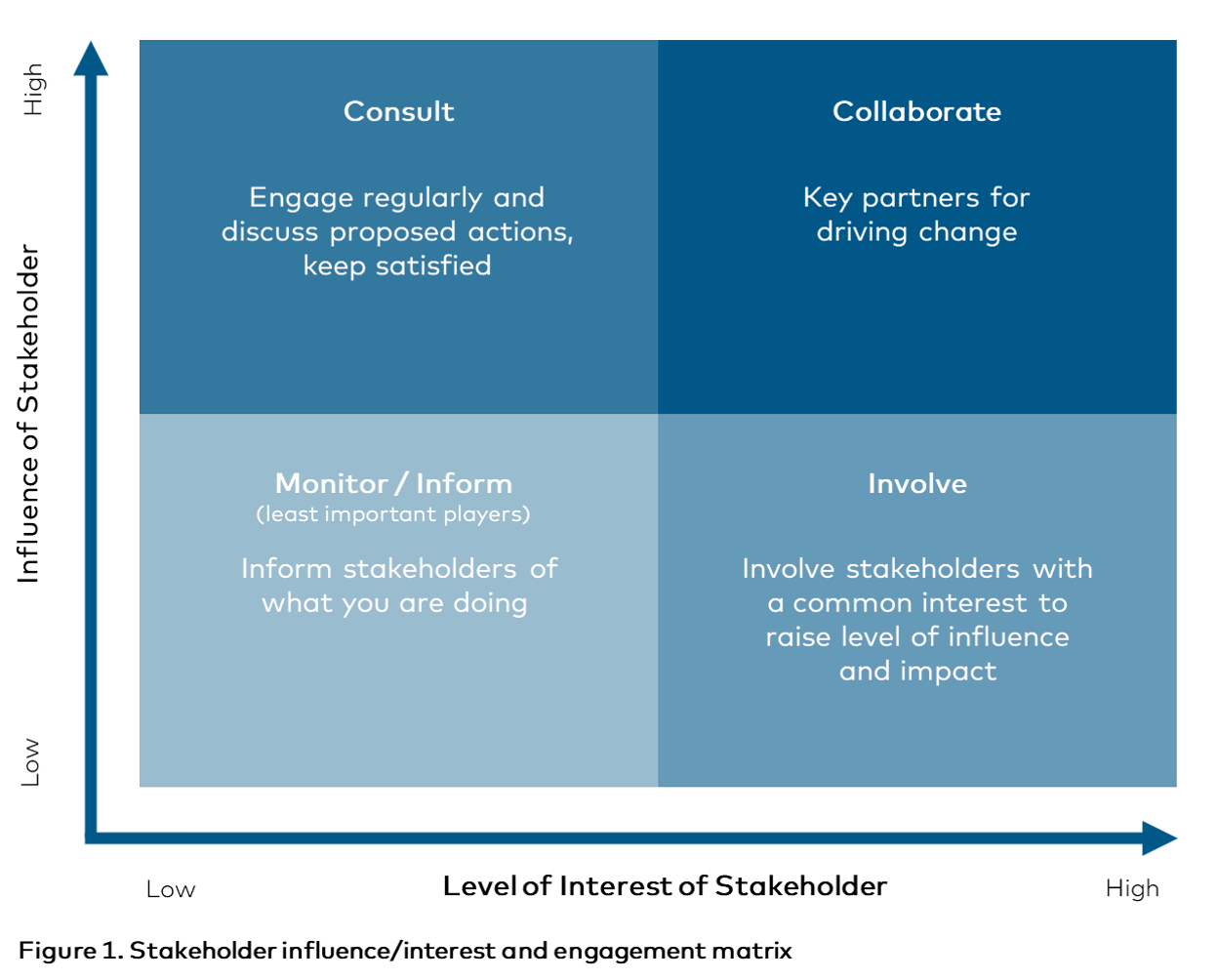
Understanding stakeholder interests and influence helps to inform the site's stakeholder communication, engagement and water stewardship strategies (Steps 2-5). Methods of influence include:
- Partner: Work together as equal partners to address a common water challenge.
- Involve: Where the site takes a lead on an initiative and involves other organisations or groups with a common interest.
- Consult: Actively meet or discuss proposed actions.
- Inform: Let stakeholders know what you are doing, allowing them to respond if they have questions or concerns. Communication may be, for example, by letter, email, posters, mailbox pamphlet or newspaper announcement.
- Reciprocate: Explore if there is action you can take in return.
The interest/influence matrix is a useful model to create a visual analysis of your stakeholders and how you might communicate, engage and collaborate with them. However, this is just an example approach. The site can make it's own judgement on how to respond to this criteria and indicator.
See Figure 1.
# 1.3 Gather water-related data for the site
# 1.3.1 Provide copies of any existing water related site plans
The organisation needs to be aware of water-related emergencies and be prepared to react to them. This indicator requires the site to identify any existing emergency-response plan it has (if any) that addresses water-related risks and events. It may be part of a general incident response plan or may be specifically for water-related events.
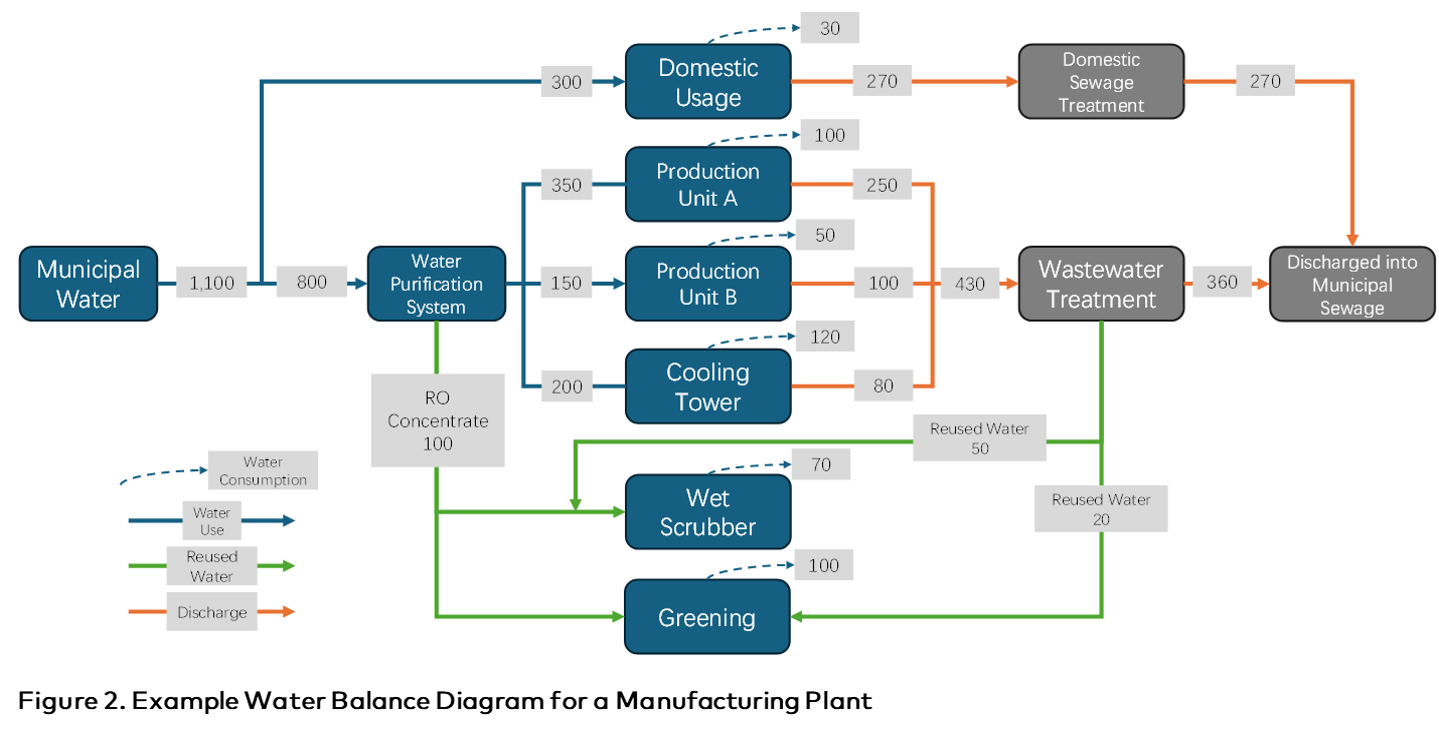
# 1.3.2 Describe and provide a map of site water balance
Water Balance: An assessment of all water flows and storage volumes of an entity. The assessment should measure all water inflows, throughflows, outflows, water storage volume and changes in storage.
The first step is to identify and map each component, and then to quantify it (Indicator 1.3.3). The locations of key flows and storage should be shown on a scaled site map. For numeric information, it may be clearer to show these on a schematic diagram (see example Figure 2).
- Typical water inflows are from incoming water supply and onsite rainfall (if used or stored). Rainfall that drains quickly offsite need not be included. In rare cases, water contained in incoming materials (such as fruit, vegetables or dairy) is extracted and used as process water. In these cases the water should be included in the balance.
- Typical outflows include: Wastewater, run-off (e.g. from drainage areas or washing facilities), leakage, evaporation, and water contained in manufactured product (e.g. beverages)
- Typical water storage components include: Water storage facilities (open reservoirs, closed tanks), fire-fighting water tanks, and water contained in pipework (which can sometimes be significant).
# 1.3.3 Provide water quantity information for site, including threats
The site should quanity all water inflows, throughflows, outflows, water storage volume and changes in storage. These are combined into the water balance equation, which should balance (at least approximately).
The water balance equation: (Water outflow) = (Water inflow) + (Change in storage volume)
The water balance equation must balance and so is useful for verifying that water volumes and flows are reliably measured and accounted for. For example, if measured outflows are too small compared to inflows, it can be an indicator of unaccounted for leakage or evaporation. Some water flows, or volumes are easy to measure, such as with flow meters or known water tank volumes. Others may have to be estimated. For example, nonpoint source losses such as underground leakage (which can be difficult to measure), evaporation and run-off cannot usually be measured directly. Given that it may be difficult to accurately measure some flows, an error of up to 5% difference between inflows and outflows is acceptable.
A basic water balance is commonly done on a one-year timescale. It may also be appropriate to calculate it for shorter timescales: seasonally, monthly, weekly or daily. A monthly timescale can be appropriate when there are significant seasonal variations in water use or availability. Weekly or daily timescales are appropriate when there is significant short-term variability in how water is used operationally.
Annual variance in water usage rates highlights the importance of understanding the variability of water demand through the year and how it correlates with availability. The site needs to know whether water availability and system flexibility are sufficient to meet peak demands. For example, irrigation rates are often higher in the driest times of the year, or drinks production can be higher in warmer times of the year when consumer demand is higher. A site needs to know whether the water supply system (whether municipal network, river, reservoir, aquifer, etc.) can meet its demand rates without negative impacts on the natural environment or other water users. Where there is an impact, or high risk of impact (water-related challenge), then the high and low variances (peak/low availability and peak/low demand) should be quantified.
To do this, the site should monitor its water usage rates through the year (ideally over a number of years) and identify and quantify its highest and lowest rates. It should also understand what the available supply rates are across the year, which may vary due to seasonal changes or demand. For example, water demand may increase in the summer. How to do this depends on the type of water supply:
- For a municipal supply, the utility/supplier can advise at what extraction rates the site can draw water, which may be constant through the year or variable.
- For a private water supply, the rate may be limited by the physical capacity of the water source or by permit conditions. The water body (surface water or aquifer) may have less availability at certain times of year, due to lower water levels or flows, which in turn may be due to seasonal weather conditions or increased demand by other water users.
- See also Indicator 1.5.3 regarding catchment water balance and understanding potential water supply and scarcity risks.
A condition where peak demand matches or exceeds what is available is a risk. The ideal situation is to have a buffer between availability and peak demand to reduce the risk of a limitation in supply and other negative impacts.
# 1.3.4 Provide water quality information for site, including threats
Water Quality: The quality of a water body or source in terms of physical, chemical and biological parameters.
Water quality information is important for understanding risks to the organisation and showing whether the organisation’s wastewater has a negative impact. The site should maintain records (a recommended minimum five years) of the quality of all incoming water supplies, outgoing effluent (after treatment where applicable) and of water bodies that receive the effluent.
For its own water sources and wastewater discharges, the organisation will usually collect its own samples on a regular basis for laboratory analyses. Water and wastewater utilities and service providers can usually provide water quality data. If not already publicly available, the organisation should request it. Note that the provider may claim that any information not legally required to be disclosed is confidential.
Water and wastewater quality data should be used to verify compliance with relevant standards. The relevant quality standards are defined by national or local regulation and guidelines. Where these are absent, then international standards and guidelines may be applied. Good water quality status is where it meets the requirements of native flora and fauna, and for human needs where applicable. Water quality status is not usually required to be pristine (ie. contaminant free) or always of drinking water quality (high water quality status), but of suitable quality for the relevant purpose(s) and within relevant standards or limits.
Where a water quality-related challenge is identified (e.g. water quality exceeds or is close to a regulatory or other accepted quality limit), the site should quantify how the quality compares to limits (for relevant parameters) and clearly identify breaches and trends of concern. For example, a drinking water parameter may be within compliance, but gradually increasing over time, indicating future non-compliance or risk for the site (e.g. health of workers) and other users of that water source.
# 1.3.5 Describe and provide a map of potential pollution sources
The organisation has a responsibility (usually legal, but also ethical) to avoid causing pollution of the natural environment, including water bodies. It is recommended to identify (e.g. list/tabulate), quantify volumes (where possible), and map all potential pollution sources, describe their nature and potential risks (resulting from spill or pollution), and identify vulnerable receiving water bodies.
Examples of pollution sources include:
- Point sources: chemical storage area, waste disposal facilities, leaks of oil or chemicals, maintenance facilities (where oils and chemicals are used), electrical transformers (a potential source of oils and PCBs), livestock facilities (where animal waste may concentrate)
- Non-point sources: site drainage channels, runoff from the use of agricultural chemicals on land (e.g. fertilizers, pesticides), and stormwater runoff.
Examples of water bodies at risk include:
- Water table aquifers, without natural protective cover (e.g. overlying low permeability layer), to which surface pollution can rapidly infiltrate
- Water supply boreholes which abstract from ‘at risk’ aquifers
- Surface water bodies which can receive site run-off, drainage discharge (from drains, etc.) or wastewater discharges. Note that storms and flood events may transport pollution farther than normally expected.
# 1.3.6 Describe and provide a map of Important Water-Related Areas
Important Water Related Area (IWRA): An area or feature of high value to humans or nature from an environmental, community, cultural, and/or economic perspective. Important Water Related Areas are deemed “important” either by local stakeholders or by key stakeholders at regional or international levels. IWRAs include areas that are legally protected or under a conservation agreement; areas that have been identified by local or indigenous communities as having significance for cultural, spiritual, religious or recreational values; and areas that are recognized as providing important ecosystem services, such as riparian areas, vernal pools critical for breeding of important aquatic species, aquifer recharge zones, wetlands that provide purification services, etc. A High Conservation Value Area (HCVA) is one form of Important Water Related Area. The term IWRA is not restricted to ‘areas’, but also applies to point features, such as a spring or water well.
The role and relevance of IWRAs within Water Stewardship One of the five intended Outcomes of the water stewardship is to achieve the ‘healthy status of IWRAs’. The organization is required to identify IWRA features on the site (this Indicator 1.3.6) and in the catchment (Indicator 1.5.5). It should also identify best practices for maintenance of on-site IWRAs (Indicator 1.8.4), and report on actions to maintain or improve them (Criterion 3.5, Indicators 3.9.4 and 3.9.9).
For this Indicator (1.3.6), each onsite IWRA feature should be listed, with a description of what it is and why it's important (e.g. it's environmental, social, cultural, or ecnonmic value), its current status, and any water-related risks. The status of an IWRA may be described in qualitative or quantitative terms. The general purpose is to gain a sense of whether the area is in good condition, improving, delining, poor condition or somewhere between. One approach could use the following 0 to 5 scale: 0. Lost or beyond a financially feasible restoration
- Severely degraded and will require considerable restoration
- Somewhat degraded and will require some restoration
- Acceptable condition but would benefit from improvement
- Good condition requiring little work apart from protection
- Excellent condition and protected requiring no work (beyond, perhaps, ongoing maintenance and monitoring.
Specific concerns, such as ‘polluted’ or ‘drying’ should be noted. Photographs of its original and current condition and any other monitoring of changing condition would be valuable. As such assessments can be subjective, the site should consider consulting with appropriate experts or stakeholders, such as local conservation NGOs. This will strengthen the credibility of assessment and may be the only true way to understand why an area is important.
Identifying IWRAs will usually require a combination of methods, combining original research and stakeholder engagement. Such methods and information sources include:
- Published maps of recognized conservation sites and legally protected features
- General maps and satellite imagery
- Regulatory and environmental agencies and water service providers
- Consultation with stakeholders, such as landowners, businesses and farms for their views on important water-related features (including their own water sources)
- Conservation groups and NGOs
- Consultation with community representatives on features of cultural value. (Note that a feature could be of value to a community not physically located in the catchment).
Where a feature is identified by stakeholders but concluded to be of insufficient status to be an IWRA, the organization should provide a justification. They should also provide justification if no IWRAs are deemed to be located on-site. See below for further guidance on IWRAs.
# Important Water Related Areas (IWRAs)
There are four main categories of IWRA: environmental, social, cultural, and economic, as explained below. Many features cover more than one of these categories. For example, a spring may have both cultural importance and economic importance as a drinking water supply. A wetland of environmental importance may also have an important role in filtering out agricultural pollution.
The term ‘important’ can be subjective. For some features, it is clear they are important, for example, a public water supply borehole or a protected wetland. For others, it can depend on local tradition or the views of stakeholders, including indigenous peoples. A feature need not have an official designation to be considered ‘important’ to the local community. They should be identified through appropriate research and consultation (i.e. with stakeholders identified at Criterion 1.2).
The term ‘water-related’ includes not only water bodies, but encompasses areas or features that are linked to, or dependent on water for their condition and protection. This includes wetlands, marshland, riverbanks, riparian areas and floodplains. It may include an area that is dry for much of the year, but which depends on periodic flooding to support its ecosystem. However, the assumption is there will always be a link to water.
Environmental importance The environmental importance of IWRAs includes natural features supporting landscapes and ecosystems. In addition to their aesthetic value, they are essential for supporting aquatic wildlife and species on their boundaries. They may be essential breeding grounds for birds, and they are often a source of water and food for birds and other passing or temporarily resident wildlife. An IWRA may be important for providing water volumes, protecting water quality or both. Examples include:
- Water features: river, stream, spring, waterfall, lake, pond
- Wetlands (which are often a mix of open water and land with shallow water table)
- Recharge zones for aquifers
- Designated conservation sites (international, national, regional or local)
- Special or unusual features such as peatlands and karstic systems (cave systems created by water erosion and dissolution over geological timescales).
Community importance IWRAs provide sites, resources and features essential to meeting basic needs. Examples include water sources for drinking water (e.g. hand-dug wells, boreholes, springs, surface water bodies used for that purpose); and freshwater animal or plant populations relied on by communities for food or other benefits.
Cultural importance Water-related features may have important cultural, religious or spiritual value to the community or indigenous peoples. These are features that, more than any other, will require effective stakeholder and community engagement to help with identification. Examples include waterfalls, springs or lakes of special cultural significance; or mineral water springs.
Economic importance Water is essential for economic development and stability, for general drinking water supply, for industry and for agricultural irrigation. Any water feature providing a direct supply is clearly of economic importance. There is also economic value in the ecosystem services that water features supply. This can include climate regulation (e.g. humidity and air-cooling effects), flood alleviation, supporting pollinating insects and supporting fish stocks for food.
# 1.3.7 Calculate and decribe or document annual water-related costs, revenues, and non-financial value-add
Water-related costs are often broader than initially perceived; they include more than just procurement of water and treatment of water. They include all costs related to understanding and managing water stewardship. The site should be aware of the scope, for both short-term and long-term investments and be able to demonstrate it has the financial commitment and resources to support them.
The cost analysis should consider, but not be limited to items such as: payment for experts, fees and levies, data collection, technical studies, capital investments and depreciations, risk mitigation actions, stakeholder engagement activities, external communications and staffing, being either ‘one-time’ actions or events, or operational expenses, and for ongoing monitoring, maintenance and management of water resources.
In most cases, a site is less likely to generate water-related revenues, but it should identify them wherever existent. Examples include provision of direct water supplies to others and provision of treated wastewater for reuse such as aquifer replenishment or irrigation. Restoration and protection of an IWRA (such as a wetland) may provide cultural or amenity value.
Further examples for water-related costs:
- Water supply (whether to external supply or internal operational costs)
- On-site water treatment Energy: to move, treat, heat or cool water
- Provision and maintenance of water-related infrastructure
- Fees for supply, permits and taxes
- Risk mitigation actions
- Stakeholder engagement and associated activities
Examples of water-related revenues
- Sale of water from the site, which could be excess water supply or treated wastewater
Examples of water-related value creation
- Contributions to restoration and protection of an IWRA which may have added benefits such as recreation, cultural, biodiversity, etc
- Free or subsidised provision of water or treated wastewater to other users. For example, treated wastewater may be donated to farmers for irrigation
- Treated wastewater contributing to local aquifer recharge. Added-value can be qualitative or quantitative, but quanitified wherever possible.
# 1.3.8 Describe or document WASH access and adequacy
WASH: Acronym for Water, Sanitation and Hygiene. It's used to refer to the combined area of effort to address basic human water needs and rights related to access to safe and sufficient water for drinking, food preparation and washing. It also includes the provision of good washing and toilet facilities and the principal of hygiene education to combat the spread of water-related illnesses and disease.
Briefly describe the nature of the drinking water and sanitation facilities on site. Explain to what extent they comply with local laws and international guidelines, such as from the World Health Organisation (WHO), taking into account people numbers, gender, age, religion, mobility, and any vulnerable groups. Where provision does not comply with law or international guidelines, an explanation should be given of why, and what efforts are in place to correct this.
The appropriate ‘level of access’ or ‘adequacy’ may depend on ground conditions, climate, local context, and cultural and behavioral traditions. WASH provision includes, but is not limited to, water points and fountains, toilets, washing facilities, hygienic areas for food and drink consumption, and potentially showers. There is much available information from various sources on the topic of WASH, some links include:
- WASH4WORK WASH Pledge: Guiding Principles (2021) and WASH Self Assessment Tool: https://wash4work.org/wash-pledge-toolbox/#1680881180565-57ff3949-0f86 (opens new window)
- UNHCR Refugee WASH Standards and Indicators (2020): https://www.unhcr.org/media/unhcr-wash-practical-guidance-refugee-settings (opens new window)
- WHO: Core questions and indicators for monitoring WASH in health care facilities in the Sustainable Development Goals (2018): https://www.who.int/publications/i/item/9789241514545 (opens new window)
# 1.4 Gather data on site's indirect water use
Indirect Water Use: Water used in a site’s supply chain representing that used in the manufacturing and provision of all products and services, excluding water used on site. In effect, it is the sum of ‘embedded water’ of all products and services.
Embedded Water: Water that was used in the production or creation of an item, but not contained within it. For a crop, it is the water it needs to grow (irrigated or rain-fed), taken up by its roots and lost via transpiration, and is usually 100s of times more than the water physically retained within the crop. It may also include water used to wash, process and transport it. For a manufactured item, it is the water used during its manufacture. For products (e.g. clothing), it includes the water to create the raw material (eg. cotton or wool), as well as that used in manufacturing. Alternative terms are ‘virtual water’ and ‘water footprint’. There are a range of methods and approaches to evaluating embedded water. Some include total water use, others only net water use. Some include the principal manufacture, others include the complete supply chain (eg. mining of raw materials). WSAP does not specify a method.
Supply Chain: The network of all suppliers and their activities that contribute to providing all materials, ingredients and services to the site to support its normal production and operational activities. The chain starts from the provider of raw materials (eg. mines) or ingredients (eg. farms), through every intermediate supplier to delivery at the site (from its direct suppliers). It includes intermediate processing and production of goods, packaging and transportation.
Water stewardship recognizes that some sources of goods and services are outside of the site but within the site’s own catchment. It also recognizes that some primary inputs come from catchments other than the site’s, and these could be at some distance from the site.
There are two principle reasons to assess indirect water use. First, it will help an organisation to understand associated risks to its own business or activities. For example, severe drought (in the site's own catchment, or in a separate catchment from the site but important to it's supply chain) may impact on the availability or cost of an essential food ingredient. Second, it is an opportunity for the organisation to influence water stewardship in it's important supply chains. Building an understanding of indirect water use, potential supply chain risks and impacts, helps the site to identify areas of common interest with key suppliers (e.g. same water source, shared risks, etc.), and potential areas of focus, action and collaboration in developing the organisation's water stewardship plan and strategy (Steps 2-5).
However, this criterion does not involve mapping a sites’s complete supply chain. That can be a complex, costly and time-consuming exercise, which, despite bringing beneficial insights, is beyond the capacity of many sites (especially small and medium-sized enterprises), and/or their ability to influence suppliers may be limited.
Rather, this criterion is about beginning to understand the importance of indirect water use, key water-dependent inputs, and giving the site some degree of understanding of its reliance upon water (both quantity and quality) and water-related risks from other locations. The expectation is that once a site has begun to understand the importance of its reliance upon water in its supply chain, it can take action if necessary and/or steadily increase this understanding over time.
Developing an understanding of indirect water use is something that is increasingly recognized as good practice, and there have been increasing efforts put into how to measure water use within the supply chain. Different sites will have a greater or lesser degree of reliance upon indirect water for their operations, and this should be considered when determining the level of expectation around continual improvement.
Sites that mainly rely upon direct water consumption for their operations and whose focus is the production of primary inputs (i.e. natural resource sectors who derive their revenues from the extraction of environmental goods – e.g. agriculture, mining, forestry, oil and gas) are likely to require less attention and a less sophisticated understanding of their indirect water use (since it is less- or non-material to their operations).
Sites that mainly rely upon input products for their operations and whose focus is on the modification/improvement of goods and services based upon primary products (i.e. sectors who derive their revenues from converting primary inputs into added value goods and services – e.g. manufacturing, processing, services) are likely to require more attention and a more sophisticated understanding of their indirect water use (since it is more or highly material to their operations). Sites that have agriculture products produced elsewhere in their supply chains are particularly sensitive to indirect water use.
# 1.4.1 Describe or document embedded water use of primary inputs
As an initial step in understanding indirect water use, this criterion requires the site to identify primary inputs, calculate or estimate the product embedded water, and understand the products catchments of origin.
Primary inputs are the materially important product(s) that a site uses or consumes to generate the product(s) or service(s) it provides as its primary function. These can be thought of as the “main ingredients” that a site needs to run (e.g. aluminium, sugar (cane), CO2, water and oranges for a site producing a canned, orange drink with bubbles). Note: primary inputs do not include infrastructure.
Generally, primary inputs should include any externally procured goods that account for over 5 per cent of the total weight of the goods generated, or 5 per cent of the costs of a site. For example, lumber, energy and water likely would be some of the primary inputs for a pulp and paper facility. Fertilizer, seeds and water likely would be the primary inputs for a vegetable grower.
Note: In the case that there is an input that does not meet this generic threshold (e.g. it is only 3 per cent by cost) but is significant in its water use (whether regarding quantity and/or quality) these should be included (if known). Through time, a site should work to make these determinations and distinctions to fully understand risk exposure through indirect water use in it's supply chain.
To conduct a simple indirect water use calculation:
- Gather a list of primary input commodities for the site.
- For each input, quantify its total annual consumption by the site (in kg, t, L, ML, or unit as appropriate) and identify its country/region/catchment of origin.
- For each input, identify (and if possible, quantify) any water quality parameters of concern.
- Look up the embedded water or water footprint for each input through existing calculations (the site is not expected to generate new data, but rather draw upon existing data).
- Multiply the site's annual consumption amounts against the appropriate commodity/source region water footprint values to get an estimate of total footprint.
- Using readily available tools (e.g. WRI’s Aqueduct Water Risk Atlas, or WWF Water Risk Filter), review source locations to determine whether any water concerns or risks are present in the catchments where the product is sourced (e.g. water scacity risks, water quality or stress risks). Note any products/source areas of concern that should be considered. These are the commodities that may experience price volatility or availability interruptions; therefore, consider alternative sourcing options and consider building into contingency planning.
Where products are compound (e.g. an electronic circuit board with various plastic and metal components) and it is difficult/impossible to determine a simple indirect water use calculation, the origin should still be noted to determine if the product is being manufactured in a water stressed catchment.
Where embbeded water/footprint data doesn't exist (per the above methodology), which is likely the case for composite inputs, the site is not expected to generate primary data. However, it is still expected to note the country/region/catchment of origin wherever possible and whether the area experiences water risks (per the last step in the above methodology). The preference is to link the primary input to a catchment and note (and understand) that catchment’s water stress.
Where products derive from commodity markets, this will be accepted as an end point that need not be traced back further. In such cases, global indirect water use numbers should still be used and through time, sourcing should be determined and/or estimated.
Several other well-recognized methodologies have emerged in recent years to measure indirect water use, most notably ISO 14046 Water Footprint Life Cycle Analysis methodology.
For sites that rely upon indirect water, this criterion is based upon the premise of continual improvement. That is: an ever-improving understanding of the sources of indirect water use, including identifying the most material inputs (from a water perspective), better understanding the status of the source catchments, and improving the temporal and spatial resolution of the site’s understanding over time. Initially, the organisation should show it has made a reasonable effort to gather the information, particulaly for goods sourced from within the site’s same catchment(s), and then for goods sourced from other catchments with high water risk and/or priority for the site. The organisation is not expected to undertake original studies or measurements, but to seek existing information. Sources of information may include:
- The supplier of the goods or services (who may already have undertaken an assessment of its own water use)
- Water management agencies (e.g. water regulators), who may already have good knowledge on the water users in the region or catchment.
- Sector or commodity-specific studies on water use. For example, ‘water footprint’ studies or studies on water use by relevant industry sectors
- Water-related risk assessment using online tools such as WRI Aqueduct Water Risk Atlas, or WWF Water Risk Filter.
# 1.4.2 Describe or document embedded water use of outsourced services
Outsourced services that consume water are typically processes that are required for the ongoing operations of the site. This is often, but not always, connected to cleaning services but may also relate to sanitation services or other water-related services. Examples of indirect water use in outsourced services include offsite laundry services and offsite vehicle washing.
For embedded water use in outsourced services the site should, as far as possible:
- Provide a list of outsourced services that consume water or affect water quality, and identify the catchment(s) of origin (where the service operates or impacts upon).
- For services originating from the same catchment, the origin of the water and wastewater receiving bodies (e.g. water services provider or water bodies).
- Quantify the water volume used by the outsourced service(s) (e.g. Mm3 or m3 per year or better) (proportioned to the site’s use).
- Identify, and where possible quantify, water quality parameters of concern.
- Using readily available tools (e.g. WRI’s Aqueduct Water Risk Atlas, or WWF Water Risk Filter), review whether any water concerns or risks are present in the catchment of origin (e.g. water scacity risks, water quality or stress risks).
When quantifying water use, it is important to distinguish 'total water withdrawal' from net water use or consumption. For example, electricity production may use large volumes of water for cooling, but most of this is returned to the local water cycle, with relatively little net impact (or consumption).
As for Indicator 1.4.1 , for sites that rely upon outsourced services, this indicator is based upon the premise of continual improvement. That is: an ever-improving understanding of the sources of indirect water use, including identifying the most material inputs (from a water perspective), better understanding the status of the source catchments, and improving the temporal and spatial resolution of the site’s understanding over time. Initially, the organisation should show it has made a reasonable effort to gather the information, particulaly for goods and services sourced from within the site’s same catchment(s), and then for goods and services sourced in other catchments with high water risk and/or priority for the site.
# 1.5 Gather water-related data for the catchment
Criterion 1.5 is similar in approach to 1.3, but instead looks beyond the site, into the site’s catchment, and where noted, to the catchments of origin of the primary inputs. The Standard recognizes that moving beyond the site into the catchment introduces increased complexity and level of effort.
The organization is not required to physically collect catchment data (e.g. undertake catchment water quality testing or water balance calculations) itself but may use existing data and information from other sources and studies. The organization is usually best able to collect data from its own site, but for the surrounding catchment, relies on other sources being available.
It's acknowledged that the availability of publicly accessible data and information on water varies enormously across the world. In developed countries, it is commonly comprehensive. For example, Australia has detailed geological maps and publicly-funded databases with detailed information (geographically and over time) of surface water bodies, aquifers, water quality, flows and their variability, climate, water withdrawals, and water resources availability. This information may be in the form of reports, maps or databases, on or offline. In addition, there are many thousands of academic studies available on water resources, mostly available online, and for free or for a reasonable fee.
In developing countries, or remote and less densely populated areas, there may be relatively little information available. Where relevant data cannot be identified, the organization should show it has made a reasonable and proportionate effort to do so. Experts with local experience will have valuable knowledge and will also know where, or to whom, to go for additional information and data. Water resources experts will have experience in ‘on-the-ground’ assessment to understand the catchment, local water issues, land use impacts and Important Water Related Areas.
Participants in the WSAP Verification Programme can refer to the 'Catchment Assessment' for their catchment in the Catchment Assessment page in the Member's Portal. The purpose of the Catchment Anssessment is to gather key catchment and water information related to this Criterion 1.5. This then aims to assist water stewards in identifying shared water challenges in the catchment (Criterion 1.6) and potential opportunities for addressing them. WSAP works to keep the Catchment Assessments up to date (approx. annually), however, it is the responsibility of users to check the information and seek further clarification from relevant agencies, stakeholders, or experts where required.
Users and stakeholders are welcomed to provide information to support the Catchment Assessment to assist water stewards in improving catchment outcomes. Please contact WSAP with queries, feedback or for further information about the Catchment Assessment.
# 1.5.1 Describe water governance initiatives
Water governance: Water governance refers to how water supply, wastewater, water resources and the associated natural environment are managed by government agencies, institutions and other organisations. It includes water resources management, protection, allocation, monitoring, quality control, treatment, regulation, policy and distribution. Good water governance ensures responsible sharing of water resources in the interests of users, the natural environment and furture generations, in line with the principles of water stewardship and society’s goals.
For most countries, water governance responsibilities are separated into logical and manageable geographic areas, which may be based on river basins, geology, geography (catchments and sub-catchments), or political/administrative boundaries. Transboundary water governance referes to the management of shared water resources across multiple political or administrative boundaries (e.g. states, provinces, countries) . It's a complex issue that involves diplomacy, cooperation, and investment.
Developed countries typically have advanced and comprehensive water governance programs, including policy, regulation, enforcement, and (sometimes) community enagement initatives. Where water governance institutions, policies and frameworks already exist for a catchment, region or country, it is important to be familiar with them and to work with them.
Where catchment water governance is non-existent, limited or poorly implemented, the organisation has more potential, and in some cases, the responsibility to influence its improvement.
The site should document it's relevant water governance institutions or stakeholders (see also Criterion 1.2 on identifying stakeholders), and their water management initiatives, plans, policies, and goals relevant to the catchment (where available).
This links closely with Indicators 1.6.1 (Provide a prioritised list of shared water challenges) and 1.6.2 (Describe or document initiatives to address shared water challenges).
The site should also understand how changes are planned and made, and the potential impact of any intended new plans and policies on its own operations and be prepared for these (see also Indicator 1.7.1 on identifying site risks). Examples of policies with possible impacts requiring forward planning are:
- The water resources of the catchment are judged to be over-allocated. There is a policy to reduce or withdraw some allocations to bring the catchment back into balance.
- There is a plan to significantly increase municipal water supply charges in order to encourage efficiency and raise funds for essential renovation and upgrades of the water supply infrastructure.
- There is a plan to apply stricter limits on the quality of wastewater received by municipal treatment plants, so some businesses will have to install their own pre-treatment facility.
- Plans to increase public investment in water supply will reduce the occurrence of supply interruptions, thus creating a beneficial impact.
- Strengthening of water quality and effluent standards.
- Policies that would re-prioritize water allocation to benefit other water users who may be disadvantaged by current arrangements.
# 1.5.2 Describe or document water-related legal and regulatory requirements
Water-related legal and regulatory requirements applicable to the site should be understood and complied with regardless of any stewardship commitment. These will typically include, but not be limited to, standards for:
- Water quality
- Water pricing
- Water volume limits
- WASH requirements
- Wastewater discharge standards
- Environmental regulations to protect water bodies and conservation areas from pollution
It is important to be fully aware of any licenses or permits with regulatory conditions for the site (such as permitted water abstraction rates and wastewater discharge quality).
This Indicator relates to Criterion 2.2 Develop and document a process to achieve and maintain legal and regulatory compliance.
# 1.5.3 Describe or document catchment water balance and scarcity
The water balance of a catchment is an assessment of water inflows, throughflows and outflows, and water storage within the source water catchment(s), usually done by catchment governance agencies, managers, researchers or stakeholders. It's a similar principle to a site water balance (Indicators 1.3.2 and 1.3.3), but on a much larger scale, and more complex (see typical catchment water balance parameters below).
Water balance is defined in a basic equation: (Water outflow) = (Water inflow) + (Change in storage volume)
The equation must balance (at least approximately) and so is useful for verifying that catchment water volumes, flows, extractions and losses are reliably measured and accounted.
The assessment helps catchment managers to manage water resources effectively and equitably, and to identify when there is a current or increasing risk of water scarcity or emergency (e.g. flooding). Water scarcity occurs when outflows are consistently larger than inflows, so that water storage and availability in the catchment decreases over time.
Catchment governance agencies and stakeholders responsible for water level monitoring, permiting, licencing, etc. are usually responsible for catchment water balance assessment and key sources of information for this Indicator. A catchment water balance is most commonly done on a one-year timescale. It may also be calculated for shorter timescales, if there is significant seasonal variability in availability and/or demand. Future modeling and projections are also relevant for understanding changing conditions and potential risks (e.g climate change projections and risks).
Important Note: Where catchment water balance is not available, it is not incumbent upon the site to calculate or complete a water balance assessment for their catchment(s). The site only need demonstrate reasonable effort in seeking or obtaining information for their site's catchment(s) and documenting where information isn't available (which could indicate a water governance challenge in the catchment). This may include contacting relevant catchment governance agencies or stakeholders for information directly if the information is not publicly available (online, research papers, etc.).
The main objective of this Indicator is to help to identify any actual or potential (current or future) risks to water balance in the catchment, that may impact on the site (Indicator 1.7.1 site water risks) and other water uses and users (Indicator 1.6.1 shared water risks). In this case, qualitative data, reports and information on the status of water availability and balance in the catchment may also be relevant.
Surface water catchment water balance parameters:
- Typical water inflows:
- Precipitation (rain or snow) – the principal input for most catchments, and often the only significant input
- Flow from irrigation canals or other conveyances bringing water from other catchments
- Flow from a river. (A standard river basin catchment includes the river’s source and tributaries. However, river inflow is relevant when the organisation’s defined physical scope is only a sub-section of a large river basin).
- Typical outflows:
- Where the main river leaves the catchment (to a downstream catchment or the sea)
- Water abstractions
- Evaporation from open water bodies
- Losses from the river bed as recharge to groundwater
- Storage components
- The volume of water in the river, lake or reservoir. Where there is flow (rivers and most lakes), it is the volume at a moment in time, not the volume that flows through it.
Groundwater catchment water balance parameters:
- Typical inflows
- For a water table aquifer, infiltration of precipitation across most of the catchment
- For non-water table aquifers (confined aquifer), infiltration of precipitation at the recharge zone (the limited zone where the geological unit that forms the aquifer is at or near the land surface)
- Downward or horizontal infiltration from surface water bodies
- Subsurface flow from one aquifer to another
- Typical outflows
- Water abstractions from wells and boreholes
- Natural outflows to springs
- Sub-surface flow to other aquifers or to sea
- Effluent flow to river beds (to ensure baseflow during long periods without rain)
- Up-flow to groundwater discharge zones (creating, for example, salt pans in desert areas)
- Storage components
- The total volume of water stored in the pores and fractures in the rock. To calculate, the volume of saturated rock is multiplied by its porosity (the percentage of open pore space to solid rock). For water table aquifers, the water volume will change as the water table level fluctuates.
- Some geological units contain large cave systems (known as karstic aquifers) which may contain large volumes of water, behaving more like underground rivers.
Other water balance considerations:
- Combining surface water and groundwater
- Depending on local conditions, geology and how water is used, a catchment water balance could be based on surface water only, or groundwater only. However, in many cases, it is necessary to combine the two where there is significant surface-groundwater interaction (See ‘Catchments’ section) or when a site uses, or interacts with, both surface and groundwater.
- Fossil water aquifers. Some aquifers contain fresh water originating from recharge over geologic timescales. These are common in what are now arid areas, such as North Africa and the Middle East. During the last ice age, these regions had much wetter climates. The water contained in such aquifers is considered ‘fossil water’. When abstracted, it will not be replenished under present day conditions or within human timescales. Therefore, if water is abstracted, there will be minimal, if any inflows, to balance it, and storage will gradually decline, making this type of source functionally “non-renewable”. See the special subject guidance on ‘Fossil water and desalination water’ (pending).
Water balance considerations for agriculture:
- Soil water. For arable agriculture, a significant component of water storage is in the soil, and therefore needs to be included in the catchment water balance. Non-irrigated crops obtain 100% of their water requirements from soil water. Water from precipitation, run-off (and irrigation when applied) infiltrates the soil where it is absorbed and stored between the soil particles. Not all precipitation is absorbed by the soil. Some of it continues downwards to recharge underlying groundwater. Some larger plants, such as trees may have roots that extend deep enough to tap water directly from the water table.
- Evapotranspiration. Water losses from arable fields consist of transpiration (where water absorbed by the plant eventually transpires from the leaf surfaces), and evaporation, direct from the soil surface, especially in hot dry conditions. Together these are termed ‘evapotranspiration’ and form a significant component of water outflow in agriculture.
- Sub-surface flow to other aquifers or to sea
- Effluent flow to river beds (to ensure baseflow during long periods without rain)
- Up-flow to groundwater discharge zones (creating, for example, salt pans in desert areas)
# 1.5.4 Describe or document catchment water quality status
Knowledge of catchment water quality helps an organisation to understand any risks it may face, and its own potential to impact on catchment water quality.
Potential risks to the organisation are most important where it has its own water sources. For example, an increasing level of salinity or of a specific parameter, such as nitrate, may eventually impact the organisation’s water quality compliance (e.g. for drinking water or food processing). It could also mean the organisation needs to introduce or increase investment in water treatment.
Where an organisation is applying chemicals to land (e.g. in agriculture) or has its own wastewater discharge facility, it has the potential to contribute to water quality concerns in the catchment. For example, elevated nitrate (N) and phosphate (P) concentrations in groundwater and surface water are often the result of fertilizer use. High N and P in surface water (from run-off or groundwater out-seepage) can cause eutrophication, whereby the N and P promote excessive growth of algae, leading to oxygen deprivation for native species.
Water abstractions can also impact on aquifer water quality. For example, high rates of pumping can cause saline water to be pulled into an aquifer along coastal areas (saline intrusion), or ‘up-coning’ of deep saline water from the lower levels of some aquifers.
An initial assessment of catchment water quality will help define a baseline, but also help identify whether the organisation may already be contributing to problems.
Water quality data for the catchment may be obtained from various sources. There may already be comprehensive data available, for example from regulators, environment agencies and academic studies. Other stakeholders may also have data to share. Where existing data are limited, the organisation might consider water quality sampling from a relevant range of monitoring locations (e.g. upstream and downstream from the site to measure potential change or impacts caused by the stite, but should be done with the support of an expert).
The organisation should describe or document its findings and review potential risks, both to the site (Indicator 1.7.1) and/or other users and uses in the catchment (Indicator 1.6.1). Where appropriate, corresponding actions should be included in the water stewardship plan (Step 2).
# 1.5.5 Describe and provide a map of Important Water-Related Areas
Research should be undertaken to identify Important Water Related Areas (IWRA) and features within the site's catchment and to define their value, with a focus on IWRAs within the site's physical scope (Indicator 1.1.1). I.e. the site does not need to identify and describe all IWRAs within all the site's catchment(s), but must for those that the site materially impacts or influences upon (e.g. that rely on surface or groundwater sources that the site extracts from, or receives effluent runoff from the site, or is of important cultural value or public amenity to the local community). This is especially important if there is any possibility that the organisation could have (or be accused of having) an impact on the IWRA.
Methods for identifying IWRAs include:
- Review of maps and databases, both standard geographical maps and specialist maps and databases, such as recognized conservation sites.
- Consultation with relevant stakeholders, such as environment agencies, conservation NGOs, wildlife groups, fishing clubs, landowners.
- For IWRAs with cultural value, consultation with community and Indigenous peoples’ representatives
Catchment IWRAs should be mapped and listed, with a description of what they are, their value (environmental, community, cultural), their status and any water-related risks.
Regarding status, it should be reported whether they are in good, poor, deteriorating or improving condition. Specific concerns, such as ‘polluted’ or ‘drying up’ should be mentioned, and any management, monitoring or improvement plans for the IWRA should be referenced.
# 1.5.6 Describe and provide a map of or document water-related infrastructure
For organisations relying on municipal water supply, the status of the infrastructure may be a critical risk. If the organisation uses only private water sources, the status of catchment infrastructure (for water and wastewater) remains relevant to understanding the water challenges of stakeholders.
The organisation is not expected to undertake a detailed study of public supply infrastructure. Instead, it should develop an understanding of the general scale and condition of infrastructure in the catchment. This can usually be achieved through publicly available information and/or consultation with authorities and/or water supply bodies.
Important measures are the percentage of the catchment population with access to safe and sufficient drinking water, and the percentage connected to wastewater collection and treatment services.
In many locations, public water and wastewater infrastructure is decades old, built with obsolete materials and methods, and subject to leaks and failure. It is highly costly to repair and replace. For this reason, many governments and authorities cannot afford a comprehensive upgrade and instead aim to invest just enough to keep ahead of the worst failings. It is important to recognize and acknowledge this limitation.
It is important to be aware if infrastructure is in a particularly poor condition with limited plans for improvement. In this case, a business reliant on public supply will be at increasing risk of supply interruptions and limitations, and at greater risk of contaminated supply.
The most useful information will likely be available from water management and public water supply and wastewater agencies, for whom ownership, maintenance and infrastructure upgrade planning will be part of their responsibilities. Some authorities or supply agencies may be reluctant to share information that could expose weaknesses or problems.
As far as practicable, the site should provide a summary of the extent of water infrastructure, its general condition and percentage of catchment population served. It should report on any regular problems, on risks and include an overview of policies for upgrade (for example, to meet growing demand) or risk mitigation (for example from extreme events, such as drought). Where information cannot be obtained, an absence of information can present a risk.
# 1.5.7 Describe or document catchment WASH adequacy
This indicator has some overlap with 1.5.6. The organisation should identify the percentage of the catchment population with access to good water and wastewater services. It is not required to do its own research, but can usually get the information from other sources, such as government agencies or NGOs.
In developed countries, it is usual for nearly 100% of the population to have access to adequate WASH facilities. In developing countries or in remote areas, provision may be very limited. An absence of municipal infrastructure does not necessarily mean WASH provision is poor, as individual properties may have their own reliable and safe water supply and sanitation systems.
There remain many parts of the world where WASH provision is poor, perhaps due to poverty or poor governance and government investment.
# 1.6 Understand shared water challenges
# 1.6.1 Provide a prioritised list of shared water challenges
Shared water challenges are those shared by the site and one or more of its relevant stakeholders (as should be identified in Indicator 1.2). Examples include physical water scarcity, deteriorating water quality and regulatory restrictions on water allocation.
Shared water challenges may exist in the same catchment(s) as the site, and/or in other high risk catchments in the organization's supply chain. Understanding shared challenges provides an opportunity for collective action in the catchment and to guide the site's water stewardship plan (Step 2).
Building on the information and understanding gathered above, in particular Criteria 1.2 (stakeholders and their water-related concerns) and 1.5 (catchment data), the site should list and describe shared water challenges, and prioritise them in terms of their significance and urgency. WSAP does not precribe the how to prioritize shared challenges, due to the many diffierent possible circumstances and contexts, so judgements should be made by the site with documented justification for their prioritization.
A recommendation is to categorize shared challenges according to the main water stewardship topics and outcomes addressed above, i.e.:
- Water governance (e.g. lacking regulation, data unavailability)
- Water balance (e.g. water scarcity, flooding)
- Water quality (e.g. salinity, pollution)
- IWRA (e.g. poor health of an IWRA, restricted access to an important cultural site)
- WASH (e.g. unsafe drinking water, inadequate hygeiene facilities)
- Infrastructure (e.g. ageing infrastructure, insufficient capacity to service population needs). Many shared challenges will likely relate to multiple topics/outcomes, e.g. lack of water quality monitoring data for a catchment presents a water quality and water governance challenge, and potentially a WASH challenge. This can help sites in prioritizing and developing plans to address identified shared challenges (Step 2).
Where shared water challenges are identified, it is important to also try to understand their cause in order to accurately prioritize them, to develop appropriate mitigation actions, and to know whether collective action is appropriate. For example:
- What is the cause of a decline in water levels in a borehole? It could be due to (i) high extraction by nearby users, (ii) a broader decline in water levels across the catchment, or (iii) because the borehole is becoming clogged. The first two can be addressed by collective action, the third, not as likely.
# 1.6.2 Describe or document initiatives to address shared water challenges
For each shared water challenge (Indicator 1.6.1), the site should research and identify any existing policies, plans or inititatives in place (or in development) to address the challenges.
As a starting point to developing mitigation or action plans to address shared challenges, it is important to first be aware of any existing efforts or plans to address them, so as to avoid duplication or conflicting actions, or to identify opportunities for sites to get involved.
This Indicator links directly with Indicator 1.5.1 (Describe water governance inititatives) but also extends to other catchment and stakeholder plans and inititatives that may exist. These may have been identified as part of the site's stakeholder mapping done for Criteria 1.2.
Not all shared challenges will have existing plans and initiatives underway, which might highlight challenges of concern that the site needs to take a lead on (particularly high priority challenges and risks for the site).
As for Indicator 1.2.2 (understanding stakeholder interests and influence), understanding shared water challenges and initiatives to address them (this Criterion) helps to inform the site's communication, engagement and water stewardship strategies and plans (Steps 2-5). Methods of influence, engagement and collaboration include:
- Partner: Work together as equal partners to address a common water challenge.
- Involve: Where the site takes a lead on an initiative and involves other organisations or groups with a common interest.
- Consult: Actively meet or discuss proposed actions.
- Inform: Let stakeholders know what you are doing, allowing them to respond if they have questions or concerns.
- Reciprocate: Explore if there is action you can take in return.
The interest/influence matrix is a useful model to create a visual analysis of stakeholders and how you might communicate, engage and collaborate with them (see Figure 1 in Indicator 1.2.2).
# 1.7 Understand site's water risks and opportunities
# 1.7.1 Provide a prioritised list of water risks
Understanding and mitigating water risks is one of the most important parts of the business case for water stewardship. By understanding the risks, and then acting to remove, reduce or mitigate them, a site will help protect itself from unexpected costs and impacts. It's also important for ensuring business continuity and protecting the employment of site workers.
Water risks faced by the site shall be listed and prioritized, including likelihood and severity of impact, potential costs and business impact. WSAP does not prescribe how to assess site water risks, due to the many diffierent possible circumstances and contexts, so judgement can be made by the site on how to address this Indicator. However, some guidance is provided below to assist sites regarding water risk.
“Water risk” refers to the possibility of an entity experiencing a water-related challenge (e.g., water scarcity, water stress, flooding, infrastructure decay, drought, cost increase). The extent of risk is a function of the likelihood of a specific challenge occurring and the severity of the challenge’s impact on the organization.
Water risks are commonly categorized into three main types:
- Physical – having too little water, too much water, water that is unfit for use, or inaccessible water
- Regulatory – changing, ineffective, or poorly-implemented public water policy and/or regulations
- Reputational – stakeholder perceptions that a site or organization does not conduct business in a sustainable or responsible way with respect to water.
Water risk is also sometimes divided into two categories that describes the source of the risk, and therefore what types of mitigation responses will be most appropriate:
- Internal Risk: due to company operations, products, and services – a measure of the risk derived from the way in which a company or organization, and the suppliers from which it sources goods, operates and how its products and services affect people and ecosystems.
- External Risk: due to basin/catchment conditions – a measure of the risk derived from the catchment conditions in which a company or organization, and/or its suppliers from which it sources goods, operate, which cannot be addressed only through changes in its own, or its suppliers, operations and requires engagement beyond the organisation.
See Figure 3.
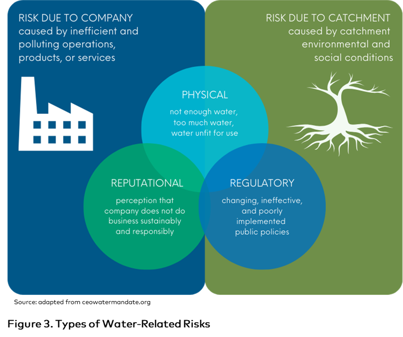
Understanding External (catchment) Risks is a particularly important and defining aspect of water stewardship, and the reason for the approach taken in the Standard to gather and understand the site's catchment stakeholders (Criterion 1.2), data (Criterion 1.5), and shared water challenges (Criterion 1.6).
The way water risks impact upon different oranizations and sectors varies greatly depending on the likelihood, severity, source of risk and type of organisation, but they can pose significant financial, health and business continuity costs and impacts, and should be comprehensively assessed and included in the organisation's overall risk management system and strategy.
Examples of water-related risks include:
- Physical risks for municipal supply
- Sudden infrastructure failure, such as breaks or leaks, leading to interruption of supply
- Contamination outbreak in supply (e.g. from pollution in reservoir, or leaky pipework)
- Regular supply interruptions (more common in developing countries with under-investment in water infrastructure)
- Vulnerability to extreme natural events (e.g. earthquake, freezing pipes and breakages due to extreme cold)
- Drought restrictions
- Physical risks for private supply
- Failed water sources, through poor condition and poor maintenance
- Restrictions on permitted abstractions during dry seasons or drought
- Pollution of the main water body (surface water or aquifer)
- Direct contamination of water source
- Failure of water treatment system
- Regulatory risks
- Breaching conditions of abstraction permits, such as over-abstraction
- Causing pollution of water bodies
- Failing quality conditions of wastewater discharge permit
- Increasing charges
- Reputational risks
- Public awareness of any regulatory breach
- Real or perceived cause of negative impacts on other water users and/or the natural water environment
- Perception that the site uses too much water adversely impacts the “social license to operate”
# 1.7.2 Investigate and describe or list water-related opportunities
Water stewardship is intended to be beneficial and constructive. It is equally as important to identify and benefit from water stewardship opportunities as it is about mitigating risks.
Examples of water-related opportunities include:
- Reducing water-related risk boosts the sustainability of the business, protects jobs, and increases the confidence of customers and investors, which can improve market share and position.
- Reducing water use will probably provide costs savings (although these may not be significant due to the typically low cost of water supply and abstraction permits). For irrigated agriculture, the greater cost savings is often in the energy used for pumping.
- Addressing shared water challenges will help achieve long term security of water needs for the site and its stakeholders across the catchment and enhance stakeholder relationships.
- Protection, restoration or enhancement of an IWRA could provide ecosystem services (or natural capital benefits), such as carbon credits, biodiversity, pest control, flood mitigation, etc.
- Pre-treatment of wastewater by a factory may save on municipal charges and provide cleaner wastewater that can be re-purposed.
- A site with its own wastewater treatment system could potentially sell the service to other nearby industries.
- Government initiatives (see Indicator 1.6.2) might provide grants or incentives for water improvement activities or technologies.
- Investors and financial institutions may provide financial incentives for sustainable business practices.
- Any positive impacts in the catchment and with stakeholders will likely create positive reputational benefits.
# 1.8 Understand best practice towards achieving water stewardship outcomes
# 1.8.1 Investigate and describe catchment governance best practice
Best practice: Not all issues or challenges have well defined, globally agreed practices, which all agree are “best practices”. Therefore, best practices can be situation-specific and defined by a variety of methods such as regulatory, scientific, and stakeholder input. Best practices can be new or innovative compared to standard practice, or in some cases, a standard and established practice may be the best. A subset of best practice is known as “Best Available Technology” which means a method, technique or procedure that has been shown by research and experience to produce optimal results, and that is established or proposed as being suitable for widespread adoption.
It's recognized that for water stewardship to applicable to all sectors and types of organizations, there needs to be flexibility and allowances for what constitutes best practice. Therefore, sites are best placed to investigate best practices relevant to their sector, organization and local/catchment context.
NOTE: Indicators 1.8.1 to 1.8.5 only requires sites to investigate and identify (describe) best practices. Whether sites plan and implement actions to achieve best practices is addressed in Step 2, Criterion 2.3 (Develop water stewardship plan) and Implementation stage, Crtierion 3.9 (Implement actions to achieve Water Stewardhsip best practice outcomes).
Examples of best practice in water governance:
- Positive participation in catchment management programs and initiatives (Indicator 1.6.2)
- Public disclosure of water monitoring data for others to use
- A comprehensive water stewardship plan that is well-implemented, routinely reviewed and updated
- Engaging with peer organisations and stakeholders to promote water stewardship
- Demonstrating support for good water governance and stewardship with appropriate authorities, including establishing or participating in Public-Private Partnerships
- Facilitating or contributing to multi-stakeholder governance platforms
- Advocating for integrated water governance at the catchment level, including supporting coordination among relevant institutions.
# 1.8.2 Investigate and describe sector and/or catchment water balance best practice
Many industry sectors now have guidance on how to improve water balance through efficiency, management, and net reduction of consumptive use. The organisation should research what guidance is available for its sector.
There is a difference between water efficiency and total water use. Water efficeincy is one measure of water use performance, but is not always sufficient. For example, a site may operate at high or maximum efficiency (in terms of water used per unit of production), but may be extracting or using an unsustainable total volume of water (such that groundwater levels are depleting, or surface water is unavailable for downstream users). Or vice versa; a site might not use the most efficient production method or technology for its sector, but their total water consumption is low due to other water saving processes or actions (e.g. water recycling). Total use is also an important measure in situations where a site is expanding or increasing production, and without water saving or efficiecy improvements will consume more water than it currently does.
Particularly in places where water scarcity is a shared challenge, the expectation is for sites to demonstrate that their total water use or consumption is sustainable (i.e. within the limits/constraints of the catchment) and, for best practice, that they are contributing positively to improved water balance and security in the catchment. This may be by way of reduction in total water use/consumtption over time.
Another water balancing practice is 'water replenishment', where sites develop projects that replenish water elsewhere in the catchment, usually to offset site water consumption. This allows for the site operations to use the volume it needs, but overall the site is still improving the catchment water balance. Such projects need not be directly related to site operations (e.g. a site can work with other stakeholders in the catchment on a project such as stormwater capture or municipal water reuse) but should occur in the catchment/area where the challenge is experienced. I.e. the site cannot 'offset' its water use impacts on one catchment with water replenishment projects in a separate catchment or area where the challenge is lower or doesn't exist.
If best practice for water balance is not clear, then stakeholder consultation and engagement may help to identify what is most appropriate for the catchment.
NOTE: Indicators 1.8.1 to 1.8.5 only requires sites to investigate and identify (describe) best practices. Whether sites plan and implement actions to achieve best practices is addressed in Step 2, Criterion 2.3 (Develop water stewardship plan) and Implementation stage, Crtierion 3.9 (Implement actions to achieve Water Stewardhsip best practice outcomes).
# 1.8.3 Investigate and describe sector and/or catchment water quality best practice
Water quality can be applicable to incoming water, but also to outgoing wastewater.
Some examples of best practice on water quality include:
- Match water quality to its intended purpose. For example, some industrial uses do not require drinking water quality water. Using a lower quality water can reserve higher quality water for essential purposes, and can result in savings on water treatment costs, and associated chemicals and energy requirements.
- In agriculture, select crops may be suited to the available water supply without the need for treatment. For example, some crops can tolerate mildly brackish water (for example, 2000 mg/l of dissolved solids).
- Use wetland treatment systems to fully or partially treat wastewater. This can have a range of benefits, including reducing energy use, and creating a benefit for species diversity and attractive green/blue spaces.
- Apply a ‘water safety plan’ approach to protect high quality water bodies and aquifers. This means using appropriate land management practices to protect water bodies from pollution in the first place, so ultimate water users (e.g. water service providers) can rely less on water treatments.
NOTE: Indicators 1.8.1 to 1.8.5 only requires sites to investigate and identify (describe) best practices. Whether sites plan and implement actions to achieve best practices is addressed in Step 2, Criterion 2.3 (Develop water stewardship plan) and Implementation stage, Crtierion 3.9 (Implement actions to achieve Water Stewardhsip best practice outcomes).
# 1.8.4 Investigate and describe catchment Important Water-Related Areas best practice
For IWRAs, best practice is highly dependent on what it is, and almost always requires expert or stakeholder guidance.
Some general examples are:
- For a surface water IWRA adjacent to agriculture, establish buffer strips between fields and the feature, so as to protect it from polluting run-off.
- Establish wetland treatment systems to protect an IWRA from the run-off from roads and parking areas.
- Establish a regular monitoring program to observe any changes to or impacts on an IWRA.
- Install a monitoring borehole between the operational site and IWRA as an ‘early warning’ approach to detect any influences from the site (e.g. on water levels or quality) that could impact the IWRA.
- Support a project (either directly or via an NGO) to restore and improve the health of an IWRA.
- Support public communication initiatives (such as sign boards) to raise awareness of an IWRA and discourage actions by others that could damage it.
NOTE: Indicators 1.8.1 to 1.8.5 only requires sites to investigate and identify (describe) best practices. Whether sites plan and implement actions to achieve best practices is addressed in Step 2, Criterion 2.3 (Develop water stewardship plan) and Implementation stage, Crtierion 3.9 (Implement actions to achieve Water Stewardhsip best practice outcomes).
# 1.8.5 Investigate and describe sector and/or catchment WASH best practice
This indicator relates to both on-site WASH provision and catchment WASH provision.
The site should have already made an assessment of the level of access and adequacy of WASH services on-site (Indicator 1.3.8) against local laws and/or international guidelines, such as from the World Health Organisation (WHO), which may be suitable "best practice" guidelines for on-site WASH provision. In some areas, where catchment WASH services and provision is lacking or insufficient or a shared challenges (assessed in Indicator 1.5.7, and 1.6.1), best practice might entail the site supporting improved WASH beyond the site. In a developed context with very high rates for the provision of water supply and wastewater services, there may be little scope to provide any additional initiatives or benefits.
Some guidance and examples of best practice for on-site WASH provision include:
- WASH4WORK WASH Pledge: Guiding Principles (2021) and WASH Self Assessment Tool: https://wash4work.org/wash-pledge-toolbox/#1680881180565-57ff3949-0f86 (opens new window)
- Provision of sufficient supplies of safe drinking water for all workers, considering increased needs in hot weather.
- Provision of sufficient and high standard facilities for toilets and washrooms taking into account people numbers, gender, age, religion, mobility, and any vulnerable groups.
- Provision of showers for workers who may not have adequate provision in their own homes.
- Provide training for workers and their families on good hygiene practices, within their community if appropriate.
NOTE: Indicators 1.8.1 to 1.8.5 only requires sites to investigate and identify (describe) best practices. Whether sites plan and implement actions to achieve best practices is addressed in Step 2, Criterion 2.3 (Develop water stewardship plan) and Implementation stage, Crtierion 3.9 (Implement actions to achieve Water Stewardhsip best practice outcomes).
# Step 2 - Commit & Plan
In Step 2, Participants publicly commit to the philosophy, concept, and process of Water Stewardship; and develop a Water Stewardship Strategy and Plan.
# 2.1 Sign and publicly-disclose water stewardship commitment
# 2.1.1 Provide a publicly-disclosed water stewardship statement/ document identified and signed by senior-most manager in charge of water at the site
The commitment should include:
- That the site will implement and disclose progress on water stewardship program(s) to achieve improvements in water stewardship outcomes
- That site water stewardship implementation will be aligned with and in support of catchment sustainability plans
- That the site’s stakeholders will be engaged in an open and transparent way
- That the site will allocate resources to implement their water stewardship plan.
A commitment by senior management is essential to ensuring an organisation has the motivation for water stewardship and has the intention to provide the investments, in time, money and human resources to commence, complete and continue the water stewardship journey. External disclosure will help to ensure that the organisation remains committed, in part to protect its reputation and credibility. Internal disclosure will help establish water stewardship within the organisation’s culture and send a message to all workers on its importance.
The person signing the commitment should be someone in a position to grant and guarantee the necessary human and financial resources to achieve the organisation’s status as a water steward, and to maintain it in the long term, including the principle of continuous improvement. In the event that the individual is replaced by another in the same or similar position of responsibility, the new person should reconfirm their commitment by also signing.
# 2.2 Develop process to achieve and maintain legal and regulatory compliance
# 2.2.1 Document system to maintain compliance obligations
The requirement to gather knowledge on water-related legal and regulatory requirements is addressed in Indicator 1.5.2. The site should demonstrate its processes and procedures for itemizing relevant regulations, summarizing the compliance requirements and obligations, details of how to comply, responsible persons/positions within the organization, and having a record of submissions to the relevant agencies. The system should also record any non-compliance warnings or events, including fines, and report on corrective actions. Where a documentation system already exists, this may be referenced. With regard to the responsible person, this should refer to the job title as the individual may change.
Regulators will define the information they require to different levels of detail. Some may be detailed and specific, for example, specifying precise water quality parameters to report or with reference to relevant water quality regulations. Others may be more flexible, for example requiring a report on ‘water quality’ or requiring a demonstration that water is potable. In this case, the organisation should reference appropriate standards, whether local, national or accepted international standards, such as the WHO Drinking Water Guidelines.
Similar principles apply to other compliance requirements, such as water withdrawal limits and wastewater discharge standards.
# 2.3 Create water stewardship strategy and plan
# 2.3.1 Provide a copy of water stewardship strategy
A water stewardship strategy shall be documented that defines the overarching mission, vision, and goals of the organization towards good water stewardship in line with water stewardship outcomes and this Standard.
The difference between the strategy and plan (2.3.2) is the degree of detail. They are distinct but can be combined. The strategy is at the higher-level of vision and mission around stewardship, with overarching goals, that guides the water stewardship plan.
# 2.3.2 Provide a copy of water stewardship plan
A water stewardship plan shall be documented, including targets addressing priority shared water challenges (Indicator 1.6), site risks and opportunities (Indicator 1.7), and water stewardship outcomes (good water governance, sustainable water balance, good water quality, healthy IWRAs, and safe WASH). For each target, the plan should include:
- Actions to achieve and maintain (or exceed) it
- How it will be measured and monitored (metrics)
- Planned timeframes to achieve it
- Financial budgets allocated for actions
- Positions of persons responsible for actions and achieving targets
- The link between each target and shared water challenges, site risks and opportunities, and water stewardship outcomes
- Where relevant, the link with identified best practices (Criterion 1.8).
In creating the plan, the organisation should use the information gathered in Step 1 and supported by the leadership commitment (2.1) and strategy (2.2.1). The plan details the actions and targets for achieveing the overarching goals (defined in the strategy) and water stewardship outcomes.
Targets and actions should align with the following principles:
- Be prioritized according to the urgency and level of risk, through consultation with selected stakeholders, taking into account their interests and concerns.
- Be SMART: Specific, Measurable, Achievable, Realistic, and Time-based.
- The scope and cost should be appropriate and proportionate to the urgency and level of risk.
- Define who is accountable for what. A useful approach is to identify who is: Accountable, Responsible, Consulted and Informed (the ARCI approach). Positions rather than names are usually most appropriate, given that individuals may change.
It's recognized that the organization may not be required to improve on all water stewardship indicators and outcomes. Broadly, the organization should seek to:
- ENSURE legal compliance (minimum)
- MAINTAIN good performance
- IMPROVE on poor performance and priority shared water challenges, site risks and opportunities towards best practice. All water stewardship targets and actions (whether maintenance or improvement) should be documented.
There are two principal categories of action:
- Immediate action to address an urgent problem, a high risk issue or to capitalize on an opportunity
- Long-term action to provide ongoing protection against risk or to achieve an improvement of status via opportunities over time.
WSAP does not prescribe the format of the water stewardship plan, but a convenient way to summarize the plan is in tabular form outlining: overarching objectives; specific targets; measurement and monitoring method (metrics); actions to achieve targets; timeframes; allocated budgets; responsible persons; links to shared water challenges, site risks and opportunities, and water stewardship outcomes; and where relevant, links with legal requirements, policy commitments, industry benchmarks or best practices.
Example of an Action Plan:
Water Targets Water is contextual, that is; water and its management is informed by the organizational and catchment context in which the site, and its suppliers, operate (see also Indicator 1.7.1 guidance on water risks). By understanding and identifying priority site and catchment water risks, opportunities and shared challenges, Step 1 of the water stewardship process aims to assist organizations in developing and setting contextually-relevant water targets and action plans that address local water challenges and priorities. For example, investment in on-site water reduction/saving equipment in a water-abundant catchment to meet an enterprise or corporate level water target is a less relevant, effective and efficient use of funds and resources than targeted action and investment in a water scarce catchment, or water infrastructure to support improved access to safe water for the local community, or rehabilitation of a local IWRA for biodiveristy and flood mitigation benefits (or whatever the priorities are in the local catchment). Building on the stakeholder inclusion and engagement process started in Step 1 (Criterion 1.2 Understand relevant stakeholders, their challenges, and site’s wider influence), water stewards should also work to consult and engage relevant stakeholders on their water stewardship targets and plans.
There is much further information available on developing contextual water targets, some links include:
- UN Global Compact CEO Water Mandate, Pacific Institute, CDP, The Nature Conservancy, World Resources Institute, and WWF (2021) Setting Site Water Targets Informed By Catchment Context: A Guide For Companies: This guide aims to help companies set effective site water targets that are informed by catchment context, which can create value and lessen risks for the company and support collective action. https://ceowatermandate.org/site-targets-guide/#1711126354103-7c0a603f-bc57 (opens new window)
- World Resources Institute (2021) Toolbox for Setting Enterprise Water Targets: This comprehensive business toolbox provides resources to aid companies in assessing water use and risks, and setting robust enterprise water targets that effectively address local shared water challenges. https://www.wri.org/toolbox/setting-enterprise-water-targets (opens new window)
- Science Based Target Network, Science-based targets for nature (SBTs): Science-based targets for nature (SBTs) equips companies with a holistic and rigorous science-based framework to assess and prioritize their impacts on freshwater, land, ocean, biodiversity, and climate so they can then take on-the-ground action accordingly through targets, beginning with freshwater and land (and climate through SBTi). https://sciencebasedtargetsnetwork.org/about/what-are-sbts/ (opens new window)
- CDP provides a list of water-related objective examples under various categories that could be used as a starting point in developing a water stewardship strategy and plan. Some examples are provided below, and organizations can refer to the full list in the CDP Questionnaire and Guidance (Environmental Performance - Water Security section) available at: https://www.cdp.net/en/disclose/question-bank (opens new window)
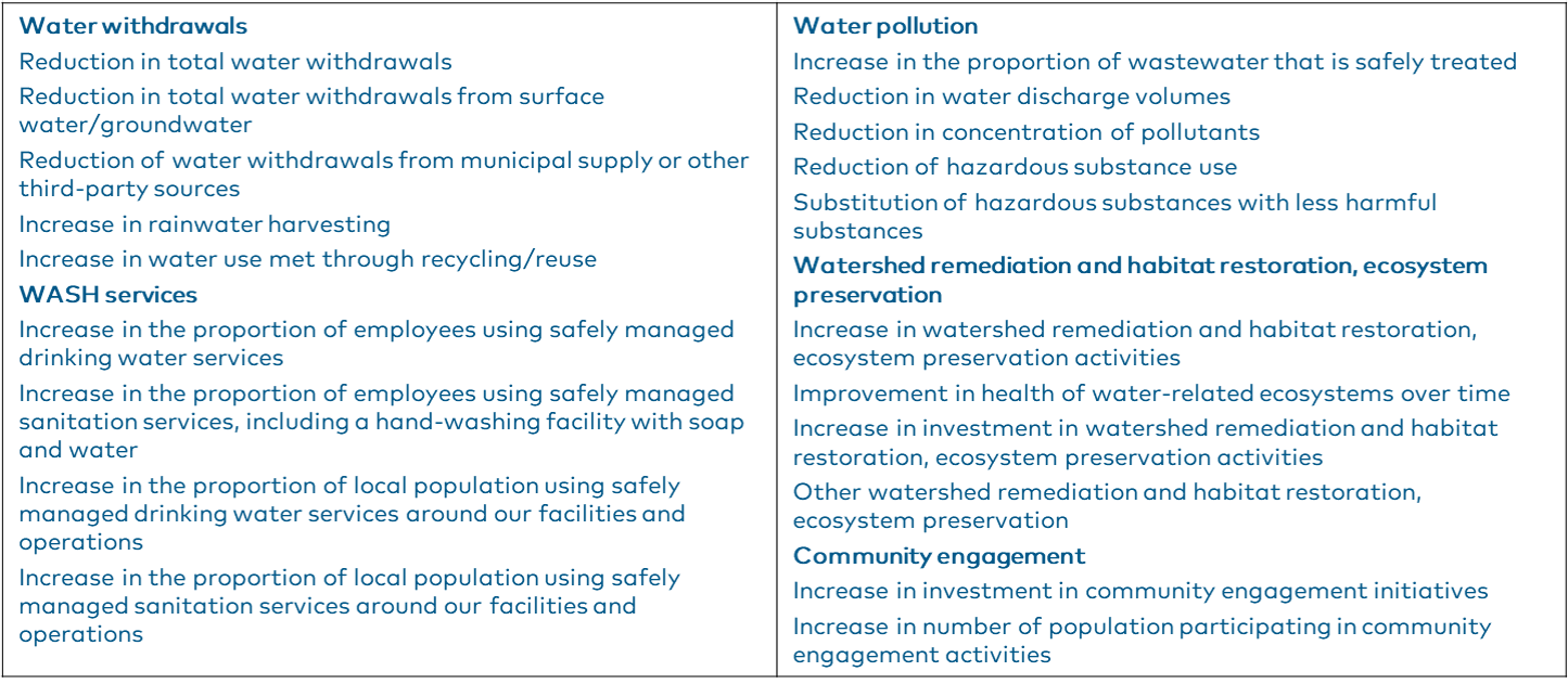
# 2.4 Demonstrate site’s responsiveness and resilience to water risks
# 2.4.1 Provide a copy of plan to mitigate or adapt to water risks with other agencies
This indicator is additional to the requirements highlighted in Criteria 1.7 (understanding the site’s water risks and opportunities). This indicator applies mainly to how the site will plan to address external risks outside of the site’s direct control or responsibility, and particularly for those risks associated with dependence on public infrastructure. These risks are not just limited to emergencies and may be short, medium or longer-term.
For example, risks under this indicator may include but are not limited to:
- For municipal water or wastewater supply: risks to the distribution infrastructure, flood risk from storms, surface water or sea level rise.
- For water sources: risks to the water body from which they abstract (surface or groundwater), such as changing water levels, flows, pollution events or decreasing water quality trends.
- Impacts from climate change, changing use, increasing population, etc. on catchment water resources or infrastructure.
Risk mitigation refers to reducing the likelihood of an event occurring or reducing exposure to it. Adaption assumes mitigation is not feasible and that the site should be prepared for the impacts.
This indicator relies on engaging with external water suppliers and managers, who should already have been identified as relevant stakeholders in Step 1. Engagement with public sector and infrastructure agencies can be an effective means to identify such risks. They may already have undertaken risk assessments to support their own business management, but they may not have openly communicated them. This engagement can also help make the relevant public sector more aware of the site’s own needs and concerns regarding its water and wastewater services.
The information for this indicator can be combined with that of 2.3 and be a component of the Water Stewardship Plan.